High performance computing: data management
When you leave a position, such as graduation from university, you usually have to backup lots of data, which is usually considered as one critical step in data management.
In general, data management is an important process in all scientific research activities. Without proper data management, research activity efficiency may be influenced. In extreme cases, you may lose valuable data due to poor data management. In some cases, it could be regarded as research misconduct as well.
Data management itself can be a project from my perspective, especially when you have to deal with massive amount of data across different platforms.
In my case, I need to manage different types of data under different environments, I will first introduce the data formats that I am dealing with, then I will introduce the file system that will be used to manage the data.
In Earth system research, data usually can be classified based on various dimensions. Based on data properties, these dimensions can be raster/vector, spatial-temporal resolutions, dateset content, etc. Ideally, you can choose any of them as index and store the data in a typical file system. However, bearing in mind that complex tree structure will also decrease the performance of data I/O.
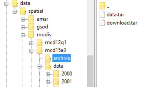
I plan not go to much details, and I will directly provide the structure I am using currently. In my case, I usually prefer to use “auxiliary”, “raster” and “vector” at the first level.
Under the second level, there are data from different sources such as MODIS and NCDC.
Under the third level , there are different products from corresponding sources. For example, if the source is MODIS, they could be “mcd12q1” and “mod17a2”.
Under the fourth level, there are several sub-directory for different purposes.
In the last level, time becomes the index. Simply, sub-directories will be named as “2001”, “2002” in chronological order.
The whole structure can be illustrated in one single picture:
There are several reasons why this structure may improve data management efficiency.
First, for HPC which use hierarchical file system as storage system, the more complex the tree structure is, the more time it will spend on data I/O. This is also the reason why object storage is becoming popular in recent years.
Therefore, we want to minimize the complexity of hierarchical structure while maintain the readability of data information.
For archive purpose, Linear Tape File System (LTFS) based storage systems are also used in my research. Even though LTFS is designed for large files, we usually do not want to throw everything into one single archive file (TAR). The good news is that LTFS has maintained the hierarchical concept, so we can manage TAR files using the same hierarchical structure. It is also very convenient to update or modify the archives.
If you look at the filename format from MODIS dataset such as this one: “MCD12Q1.A2001001.h00v08.051.2012157220450.hdf”, you may also notice that a better filename design can also help you to manage and distribute data. But that is out of the scope for now. Details the example filename can be found here.
So far I haven’t tested whether a geospatial database could further improve the data management. Since our numerical simulations need to access data, I think the complete data I/O flow will be changed and therefore may benefit from the changes. If you have any experience in this, feel free to comment.