Spatial datasets operations: a hexagon-based discrete grid systems for global simulation
After finished my three-dimensional coupled water and carbon cycle model, I have been thinking whether I can apply this approach at large spatial domain or even global scale. During this process, I realized that most (or all) global scale land surface modeling work are based on the square grid system, which is widely used in Earth science. This grid is also common recognized as pixel, grid cell.
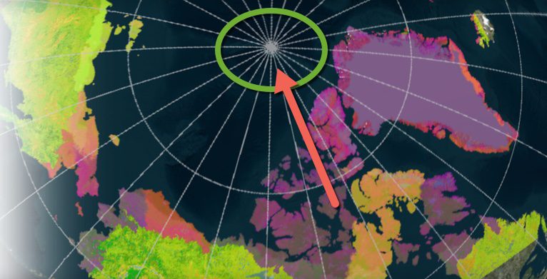
Can we still use grid in global scale land surface model simulation? Yes and no. If you do not consider lateral flow, then interactions between grid cells are omitted. In this scenario, grid cell might be the easiest approach to do so. However, if horizontal interactions are considered. Then the grid-based structure will fail. This is because latitude/longitude based structure will create singularity in polar regions like this.
And due to the distortion, it is impossible to calculate interactions within this area across polar regions.
Most maps of various variables at global scale express the polar regions as lines instead of points due to current limitation in map projections.
So what is the solution? As I mentioned in my previous post, a hexagon-based discrete grid system can be used to address this issue. To get it start easily, image Earth as a football, specifically, a soccer, then no place on this surface will be distorted and they all will have nearly the same area. Using technics in geometry, we can further divide the “faces” into smaller “faces”. Without getting into some details we can produce a discrete grid system like this:
Create a structure like this requires some program like this http://www.discreteglobalgrids.org/software/ There is also an online service similar: https://www.pyxisglobe.com/view/Explore
After this grid system is built, another problem is how we can index all the grids. Traditional cartesian coordinate system will not work well in this scenario.
In DGGRID, a Central Place Index (CPI) system is introduced to address this issue, but not implemented at all resolutions, which however provides an effective approach.
Besides, we also need to consider the relationship between grids, specifically, we need to know the neighbors of each grid in global simulation. So far I haven’t got a decent solution for the indexing problem but will update when available.
I want to thank Dr. Kevin for his help in DGGRID program and Perry Peterson on Q&A related to Pyxis.